Celestial navigation with very little math
Trammell Hudson
39th Chaos Communication Congress (39C3): Power Cycles · Day 3 · Saal One
Overview
In an era dominated by ubiquitous Global Positioning System (GPS) technology, the art of celestial navigation might seem like a relic of the past. However, Trammell Hudson's engaging talk, "Celestial navigation with very little math," delivered at 39C3, challenges this notion by demonstrating that these ancient techniques remain not only viable but also surprisingly accessible. Hudson, an individual deeply involved in sailing and maritime exploration, presents a compelling case for understanding fundamental navigation principles, particularly in scenarios where modern electronic aids may be unavailable or compromised.
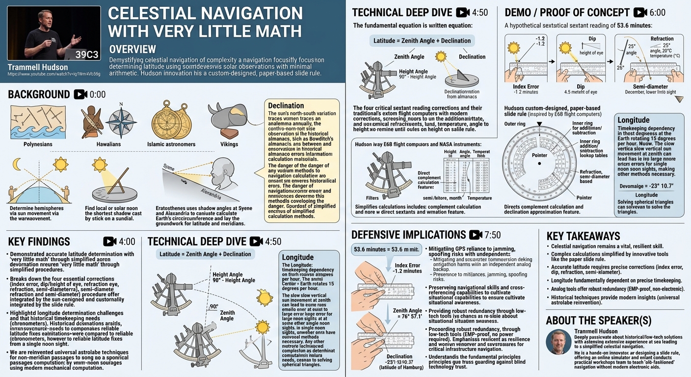
Key moments
- 0:00 Introduction to celestial navigation and historical methods
- 2:00 Simple ways to determine your hemisphere
- 4:00 Understanding local solar noon and zero shadow days
- 4:50 Eratosthenes calculates Earth's circumference with shadows
- 6:00 Using shadow angles to find your latitude
- 7:50 Historic and modern tools: cross-staff and sextant
Celestial navigation with very little math
Speakers: Trammell Hudson
Conference: 39C3
YouTube: https://www.youtube.com/watch?v=iq1WmAVb3Sg
Overview
In an era dominated by ubiquitous Global Positioning System (GPS) technology, the art of celestial navigation might seem like a relic of the past. However, Trammell Hudson's engaging talk, "Celestial navigation with very little math," delivered at 39C3, challenges this notion by demonstrating that these ancient techniques remain not only viable but also surprisingly accessible. Hudson, an individual deeply involved in sailing and maritime exploration, presents a compelling case for understanding fundamental navigation principles, particularly in scenarios where modern electronic aids may be unavailable or compromised.
The talk primarily focuses on demystifying the perceived complexity of celestial navigation, specifically the determination of latitude using solar observations. Hudson introduces a custom-designed, paper-based slide rule that dramatically simplifies the intricate calculations traditionally associated with sextants and almanacs. This innovative approach allows navigators to perform critical corrections and computations with minimal arithmetic, making the skill more approachable for enthusiasts and a practical backup for professionals.
This presentation is particularly significant in a security-focused conference like 39C3, as it implicitly addresses themes of resilience, redundancy, and the potential fragility of our reliance on single-point-of-failure technologies like GPS. By reviving and simplifying traditional methods, Hudson advocates for a robust, analog alternative that ensures navigational capability even in the absence of digital infrastructure, underscoring the enduring value of foundational knowledge and mechanical ingenuity.
Background
▶ Watch: Introduction to celestial navigation and historical methods (0:00)
The human quest for knowing "where we are" has driven innovation for millennia. Trammell Hudson begins by tracing the rich history of navigation, highlighting diverse approaches from various cultures. The Polynesians, for instance, mastered wave navigation, creating intricate stick maps representing standing wave patterns caused by local geography. The Hawaiians developed a star compass, meticulously observing the rising and setting points of constellations to pinpoint their voyaging canoes' positions on the open ocean. Islamic astronomers advanced the field with sophisticated astrolabes, tools capable of predicting celestial body positions for terrestrial navigation. Even the Vikings are rumored to have used sunstones to navigate under cloudy northern European skies.
The foundational principle of celestial navigation often begins with simple observations. Determining one's hemisphere can be as straightforward as observing the sun's trajectory at sunrise or sunset (rightward motion in the Northern Hemisphere, leftward in the Southern). A more precise method involves tracking the shortest shadow cast by a stick in the ground at local or solar noon, which marks the meridian passage when the sun aligns directly with the observer's north-south line. This observation is the basis for the sundial, whose clockwise shadow movement in the Northern Hemisphere even gives us the term "clockwise."
Historically, one of the most remarkable applications of shadow observation was by Eratosthenes in 300 BC. By noting that the temple at Syene cast no shadow on the solstice while a stick in Alexandria did, and understanding the Earth was round, he used the angular difference of the shadows to calculate the Earth's circumference with astonishing accuracy—within a few percent of modern values. Eratosthenes also laid the groundwork for modern geography, inventing concepts like latitude and meridians. The angle of a shadow at local noon, specifically the zenith angle (the angle from the zenith to the sun), is directly related to an observer's latitude.
To measure these celestial angles at sea, where a fixed obelisk is impractical, specialized tools were developed. The cross-staff was an early instrument, allowing navigators to sight the sun and horizon simultaneously, though it required direct sun exposure and was cumbersome. The sextant revolutionized this process. Modern sextants, which even found use in space navigation (e.g., Apollo 13 for re-entry, ESA projects on the ISS), employ filters to protect the eyes and a system of mirrors to bring the celestial body's image down to the horizon, allowing for precise angular measurement via a rotating scale, often with a vernier for enhanced accuracy.
A critical concept for accurate latitude determination is declination, which is the sun's north-south position relative to the celestial equator. Due to the Earth's axial tilt relative to its orbit, the sun's declination varies by approximately 46 degrees annually, tracing an analemma in the sky. This daily declination value is indispensable and is historically found in almanacs, such as the renowned Bowditch's American Practical Navigator. Hudson highlights a cautionary tale from Bowditch, where an error in treating 1800 as a leap year led to incorrect declination calculations and the loss of two ships, emphasizing the critical importance of accurate astronomical data and robust calendar computations. The complexity of working with base-60 degrees, minutes, and seconds in traditional navigation further underscores the need for simplified calculation methods.
Key Findings
▶ Watch: Understanding local solar noon and zero shadow days (4:00)
Trammell Hudson's presentation reveals several key findings centered on the democratization and simplification of celestial navigation. The overarching discovery is that the perceived mathematical complexity of traditional navigation can be drastically reduced through innovative tool design, making these vital skills accessible to a broader audience and providing a robust, analog backup to modern digital systems.
Firstly, Hudson demonstrates that accurate latitude determination from a solar noon sight can be achieved with "very little math" by systematically applying a series of corrections to a sextant reading. These corrections, traditionally involving complex lookup tables and base-60 arithmetic, are efficiently handled by his custom-designed slide rule. This finding challenges the notion that celestial navigation requires advanced mathematical proficiency, instead highlighting the power of mechanical computation.
Secondly, the talk meticulously breaks down the four essential corrections required for a precise sextant measurement: index error, dip (accounting for observer's height of eye), refraction (light bending through the atmosphere), and semi-diameter (adjusting from the sun's limb to its center). Hudson's slide rule integrates these corrections, transforming what would be a multi-step arithmetic process into a series of mechanical adjustments and readings, significantly reducing the potential for human error and speeding up the calculation.
Thirdly, the presentation implicitly reveals the inherent challenges and limitations of longitude determination compared to latitude. While latitude can be fixed relatively accurately with a single noon sight, longitude fundamentally depends on precise timekeeping—a problem that plagued navigators for centuries until the advent of highly accurate chronometers like Harrison's. Hudson notes that a noon sight is unreliable for precise longitude due to the sun's slow apparent movement at its zenith, leading to "absurdly large errors." This reinforces the historical significance of timekeeping in navigation.
Finally, Hudson's work on the slide rule for non-meridian passages, which he notes "reinvented a technique from one of the Islamic astronomers called the universal astrolabe," underscores a deeper finding: that fundamental navigational challenges often lead to similar elegant solutions across different cultures and eras. This highlights the timeless nature of these principles and the enduring value of mechanical computation for complex spherical trigonometry. The slide rule serves as a tangible "key finding" itself—a practical, resilient tool that encapsulates these simplified methods.
Technical Deep Dive
▶ Watch: Eratosthenes calculates Earth's circumference with shadows (4:50)
The technical core of Hudson's talk revolves around the practical application of celestial mechanics for latitude determination and the innovative simplification of its associated calculations. The fundamental equation for determining latitude from a solar noon sight is:
Latitude = Zenith Angle + Declination
The zenith angle is derived from the measured height angle (the angle of the sun above the horizon, obtained via a sextant) by the simple arithmetic: Zenith Angle = 90° - Height Angle. The declination is the sun's celestial latitude, its angular distance north or south of the celestial equator, which varies throughout the year due to the Earth's axial tilt. Accurate declination values are traditionally obtained from almanacs, which provide daily figures.
However, a raw sextant height measurement is not sufficient for accurate navigation. Four critical corrections must be applied:
- Index Error: This is a manufacturing or calibration error in the sextant. It's determined by observing the true horizon and adjusting the sextant until the real and reflected horizons align, then noting the discrepancy from zero. This error is then added or subtracted from the observed height.
- Dip: The observer's height above sea level affects the apparent horizon. From a higher vantage point, the horizon appears lower, leading to an overestimation of the sun's height. This correction, known as the dip, is always subtracted from the observed height and depends on the observer's height of eye (e.g., 4.5 meters).
- Refraction: As light from the sun passes through varying densities of the Earth's atmosphere, it bends, making celestial objects appear higher than their true position. This effect, governed by Snell's Law, is dependent on the sun's angle above the horizon, air temperature, and atmospheric pressure. Refraction is always subtracted.
- Semi-diameter: Sextant measurements are typically taken to the sun's lower limb (bottom edge) or upper limb (top edge) as it touches the horizon. However, all astronomical calculations are based on the sun's center. The semi-diameter is half the sun's angular diameter, which varies slightly throughout the year. This value is added for a lower limb sight and subtracted for an upper limb sight.
Traditionally, applying these corrections involves extensive lookup tables and tedious arithmetic, often in base-60 degrees, minutes, and seconds, which is prone to error. Hudson's solution is a custom-designed, paper-based slide rule, inspired by historical navigational slide rules like the E6B flight computer and specialized NASA instruments. This slide rule features:
- An outer ring for tracking minutes of the measurement.
- An inner ring capable of addition, subtraction, and housing integrated lookup tables for the four corrections.
- A pointer for precise reading of values.
The slide rule simplifies the process significantly. For example, to apply the index error, the user sets the initial measurement on the outer ring, aligns an index on the inner wheel, and then swings the pointer to the correction value (e.g., -1.2 minutes) on the inner ring to read the corrected value. The inner ring also contains scales for dip (based on height in meters), refraction (based on angle and temperature), and semi-diameter (based on month and limb observed). Furthermore, the slide rule includes a feature to directly compute the complement (90° minus the value), which is crucial for converting height angle to zenith angle without explicit subtraction of minutes from 60. Remarkably, it also offers an approximation for declination on one of its scales.
While the talk focuses on latitude, Hudson briefly touches upon longitude. Longitude determination is fundamentally a problem of precise timekeeping. Since the Earth rotates 15 degrees per hour, knowing the exact time difference between local solar noon and solar noon at a reference meridian (like Greenwich) directly yields the longitude. This challenge historically led to the development of highly accurate chronometers, such as those by John Harrison. However, determining precise longitude from a single noon sight is problematic due to the sun's very slow apparent vertical movement around its zenith, making it difficult to pinpoint the exact moment of local noon and leading to potentially "absurdly large errors" (hundreds of kilometers for an 8-minute observation window). More advanced techniques like the intercept method, which involves multiple sights throughout the day and complex spherical trigonometry, are used for accurate longitude and position fixing at any time. Hudson mentions developing tools for this as well, noting that one of his designs for solving spherical triangles effectively reinvented the concept of a universal astrolabe from Islamic astronomy.
Demo / Proof of Concept
▶ Watch: Using shadow angles to find your latitude (6:00)
Trammell Hudson's presentation culminated in a compelling live demonstration of his custom-designed, paper-based slide rule, effectively serving as the talk's proof of concept. The demonstration showcased how the complex, multi-step calculations of celestial navigation for latitude determination could be condensed into a series of intuitive, mechanical operations.
Using a hypothetical sextant reading of 53.6 minutes, Hudson walked the audience through the sequential application of the four critical corrections:
- Index Error Correction: He first set the initial 53.6 minutes on the slide rule's outer ring. Then, he applied a hypothetical index error of -1.2 minutes by rotating the inner wheel and pointer, demonstrating how the slide rule immediately provided the corrected value, eliminating the need for manual subtraction.
- Dip Correction: Next, he accounted for the observer's height of eye above sea level, using a value of 4.5 meters. The slide rule's integrated lookup table for dip was utilized, again, by rotating the appropriate scales to factor in this correction.
- Refraction Correction: Hudson then addressed atmospheric refraction, a correction dependent on the sun's angle and air temperature. He adjusted the slide rule for an angle of 25 degrees and a temperature of 20 degrees Celsius, showing how the device incorporated this variable correction.
- Semi-diameter Correction: Finally, he demonstrated correcting for the sun's semi-diameter, specifying a December observation and a lower limb measurement. The slide rule automatically added or subtracted the appropriate value to adjust the reading to the sun's center.
After applying all four corrections, the slide rule yielded a corrected minute value of 2.9 minutes. Hudson highlighted how the slide rule's design also provided the complement (90° minus the height) directly in red numbers, circumventing the need to manually subtract 2.9 minutes from 60 to find the zenith angle. This resulted in a zenith angle of 76° 57.1'.
The final step involved combining this zenith angle with the sun's declination. Hudson referenced an almanac for a post-solstice declination of -23 degrees (or -23° 10.7' more precisely). By inputting this declination onto the slide rule and performing the final addition (zenith angle + declination), the device quickly provided the final latitude, approximately 53.5 degrees, which he noted was roughly the latitude of Hamburg.
The entire process, which would typically involve "a huge amount of columns of addition and subtraction" in base-60 arithmetic, was completed in "a few seconds" using the slide rule. This live demonstration powerfully illustrated the tool's effectiveness in simplifying complex navigational calculations, making the "very little math" claim highly tangible. Hudson also mentioned having various sextants and slide rules available for a workshop after the talk, encouraging attendees to experience these "old-fashioned" methods hands-on, explicitly without laptops or calculators.
Defensive Implications
▶ Watch: Historic and modern tools: cross-staff and sextant (7:50)
While Trammell Hudson's talk is not about cybersecurity vulnerabilities or traditional network defenses, it carries profound defensive implications in the broader context of resilience and critical infrastructure protection. In an increasingly interconnected and technologically dependent world, the ability to navigate without electronic aids serves as a vital analog backup and a defense against various forms of systemic failure.
The primary defensive implication is the mitigation of GPS reliance. Modern society, from global shipping and aviation to individual smartphones, has become profoundly dependent on GPS for precise positioning and timing. This reliance, however, introduces a single point of failure. GPS signals are susceptible to jamming (intentional or unintentional interference), spoofing (broadcasting fake signals to mislead receivers), and even potential outages due to solar flares, satellite malfunctions, or cyber-attacks on ground control segments. In such scenarios, the loss of GPS could cripple navigation, logistics, and even timing-dependent critical infrastructure. Hudson's work on simplifying celestial navigation directly addresses this vulnerability by offering a robust, independent alternative.
Secondly, the talk promotes skill preservation and enhancement. By making celestial navigation more accessible through tools like the slide rule, Hudson is actively defending against the obsolescence of crucial human skills. In a crisis where technology fails, human expertise becomes paramount. Equipping individuals with the ability to "know where we are" using traditional methods ensures continuity of operations for ships, aircraft, and even ground expeditions that might lose digital guidance. This is a form of human-centric defense against technological over-reliance.
Furthermore, the physical nature of the slide rule itself offers a unique defensive advantage: it is EMP-proof and requires no power source. In an event involving electromagnetic pulse (EMP) attacks or widespread power grid failures, electronic devices would cease to function. A laminated paper slide rule, alongside a mechanical sextant, would remain fully operational, providing essential navigational computations when all digital systems are down. This highlights the value of low-tech redundancy in a high-tech world.
Finally, understanding the fundamental principles of celestial navigation fosters situational awareness and a deeper comprehension of one's position. Even when GPS is available, knowing how to interpret celestial observations provides a mental model for cross-referencing and validating electronic readings. This intellectual defense guards against blind trust in technology and cultivates a more robust understanding of the world. In essence, Hudson's "celestial navigation with very little math" serves as a powerful reminder that fundamental, resilient capabilities are invaluable defenses against an uncertain future.
Key Takeaways
- Celestial navigation remains a vital, resilient skill: Despite the prevalence of GPS, understanding and practicing traditional navigation methods provides a crucial analog backup against potential electronic system failures, jamming, or spoofing.
- Complex celestial calculations can be significantly simplified: Trammell Hudson's custom-designed, paper-based slide rule demonstrates that intricate arithmetic, especially with base-60 degrees, minutes, and seconds, can be transformed into intuitive mechanical operations, making the skill more accessible.
- Accurate latitude requires precise corrections: Determining latitude from a solar noon sight necessitates applying four critical corrections—index error, dip (height of eye), refraction, and semi-diameter—which the slide rule efficiently integrates.
- Longitude is fundamentally a timekeeping challenge: While latitude can be derived from angular measurements, accurate longitude relies on extremely precise timekeeping to measure the difference between local solar noon and a reference meridian like Greenwich.
- Analog tools offer robust redundancy: The slide rule, being a non-electronic, battery-free device, provides an EMP-proof and highly durable solution for critical navigational computations, embodying the principle of low-tech resilience.
- Historical techniques offer modern insights: The re-invention of concepts like the universal astrolabe through modern, simplified tools highlights the enduring wisdom of past navigators and the timeless nature of celestial mechanics.
About the Speaker(s)
Trammell Hudson is an individual deeply passionate about the practical application of historical and low-tech solutions to complex problems, particularly in the realm of navigation. Throughout his talk, it is evident that he has spent "a lot of time at sea," which has provided him with ample opportunity to ponder fundamental questions, including "where are we?". This personal experience at sea directly inspired his exploration and simplification of celestial navigation.
Hudson is a hands-on innovator, having personally "designed a slide rule to help" with the challenges of celestial calculations. He is also keen on sharing his work, offering an online simulator of his slide rule on his website and conducting workshops to provide practical, hands-on experience with sextants and slide rules, emphasizing learning "the old-fashioned way" without modern electronic aids. While the transcript does not provide a formal title or company affiliation, his work demonstrates a profound interest in practical engineering, historical methods, and educational outreach, often characteristic of researchers and open-source contributors in the security and technology communities. His engagement with the 39C3 conference further suggests an interest in the intersection of technology, security, and fundamental principles.
All talks from 39th Chaos Communication Congress (39C3): Power Cycles